Monday, October 29, 2007

Comet Holmes Lights Night Sky

There's a new comet in the night sky, Holmes. It's 150 million miles away, but is putting on a show over the past week.

Less than a week ago periodic Comet Holmes brightened dramatically — by nearly a million times — virtually overnight. This means all you need is some time and a pair of binoculars.

Best time to see comet is before moon rises. Holmes will look very similar to a bright star. And don't expect a tail. It appears the comet is too far away from the sun to form a tail (tail is created by the burning of the comet's gases from the sun's extreme heat).

While this comet will likely be around for weeks, Monday and Tuesday from 8-9pm will be the best times to see it. Just look in the northeast sky.

View Photos of Comet Holmes

Click here for the blog of the Roanoke Valley Astronomical Society


--Meteorologist Brent Watts

Thursday, October 25, 2007

Doppler Indicated Tornado?


In the days of warning you sooner than ever about tornadoes, there's also going to be some "crying wolf" syndrome. That came in the form of a couple emails from folks that didn't quite understand the concept of doppler indicated tornado warnings. On television, it's a bit difficult to explain radial velocity and TVS's to the average viewer, but let's give it a shot here.

Wednesday's tornado warnings were doppler radar indicated. This meant the radar was looking at wind velocity, coming toward and away from the radar, and detected twisting winds within the cloud. This twisting is the first sign a tornado is forming. Once the winds begin twisting in the cloud, there's a chance it could make it to the ground. This is why we need to warn you.

Once this tornado signature has been detected by radar, the National Weather Service office in Blacksburg issues a Tornado Warning (meaning a tornado is likely or occurring).

You may say, "why warn us about a tornado that's not even on the ground?" Good question. Even if no tornado forms, this type of warning can save lives because if a tornado does form, the advanced warning gives you precious minutes to get yourself and your family to safety. If we waited for confirmation that a tornado had already touched down, someone may have lost their life. Not to mention, many tornadoes around here are rain-wrapped, meaning the funnel cloud is obscured by torrential rain.

Luckily, no tornadoes touched down here Wednesday. 
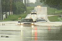
They did seem to come from out of the blue. The twisting was likely caused by a passing front to our south and areas of low pressure riding along it. Looks like the mean threat over the next 48hrs will be flash flooding from heavy downpours.Stay safe, and remember "turn around, don't drown." NEVER drive through flooded roads. This could be YOU! --Meteorologist Brent Watts

Sunday, October 21, 2007

Autumn Color - Viewer Photos


Viewers have captured autumn's beauty through the lens of their digital cameras recently. It's certainly a beautiful time of the year as our fall foliage peaks. Send your best shot to our Viewer Scrapbook.

--SkyTracker7 Meteorologist Jay Webb

Monday, October 15, 2007

Welcome Eagle Rock Elementary School!


The WeatherBug is getting bigger and bigger thanks to great schools and businesses who are joining the network. The newest is Eagle Rock Elementary School in Botetourt County. What's fantastic is that this is one of the smallest schools in the county, but have managed to raise the money to bring weather and science into the classroom.

The school is located in the northwestern portion of Botetourt County. Welcome students, faculty and parents. We hope you will use the weather data to help plan your day and to broaden your knowledge of this amazing science of weather.

Click here for the Eagle Rock Elementary Live data.

Click here for Eagle Rock Elementary School homepage.

--Meteorologist Brent Watts

Tuesday, October 9, 2007

La Nina Means Mild Winter Weather.

NOAA forecasters are calling for above-average temperatures over most of the country and a continuation of drier-than-average conditions across already drought-stricken parts of the Southwest and Southeast in its winter outlook for the United States. The report was released Tuesday (Oct 9th) and paints a bleak picture for southwest Virginia.


Movie of sea surface temperatures, January 1, 2007 - October 3, 2007. Purple and blue colors represent lower-than-average sea surface temperatures.

It appears La Nina is to "blame" for the mild winter that is forecast for the south and mid-Atlantic. La Nina is marked by abnormally cool ocean water in the equatorial Pacific. You can read the full report/forecast here, but here are some of the highlights:

  • In the Northeast and the Mid-Atlantic,temperatures are expected to be above average in response to the long-term warming trend. Snowfall for the region will depend on other climate factors, which are difficult to anticipate more than one-to-two weeks in advance.
  • The drought-plagued Southeast is likely to remain drier-than-average due to La NiƱa, while temperatures are expected to be above average.

With this said, this certainly doesn't mean we won't see any snow. Also, despite forecasting above average temperatures, you can count on some very cold periods this winter. This is a forecast, an educated prediction of what will happen 2 to 4 months down the road. Don't let your snow shovels hibernate this winter. Chances are you'll need them at least once.

--Meteorologist Brent Watts

Learn more about La Nina

Thursday, October 4, 2007

Winter Weather Outlook


It's hard to think about winter when the temperatures outside have been in the 80s for much of the week. But if you're already dreaming of making snowballs and building snowmen, you might want a back-up plan.


While much of the nation is still in summer mode, the folks at the National Oceanic and Atmospheric Administration's Climate Prediction Center have been busy running models forecasting winter weather. What are they saying?


  • Long-range weather forecasts are predicting a warmer than average winter with less precipitation for much of the United States except the Pacific Northwest.

  • NOAA forecasters believe the emergence of a La Nina condition -- unusually cold ocean temperatures in the equatorial Pacific Ocean -- will be the main factor behind the anticipated warmth for much of North America.

If you remember, the winter of 2006-07 was extremely mild for southwest Virginia, with very little snowfall and record warmth in January. Roanoke only saw 3.4" of snowfall last winter, which fell in February. A typical winter would bring an average of 23 inches of snow to the Roanoke Valley.


I don't know about you, but I'd love to see us have a big winter with lots of snow. We need all the help we can get to make up for an extremely dry summer and fall.

--Brent

Monday, October 1, 2007

Ragweed Remediation

Early fall is prime time for allergies, and in Roanoke, ragweed is the primary allergen at work right now. Ragweed plants, which only live for one season, mature as nights get longer in late summer and early fall, releasing up to one billion pollen grains per plant!

Seventy-five percent of Americans who are allergic to pollen-producing plants are allergic to ragweed, of which there are seventeen different species growing throughout the United States.

There are easy ways to reduce your exposure to outdoor allergens, including ragweed:

1) Minimize your outdoor activity in the early morning (5-10am), when pollens are usually emitted, and avoid raking leaves or cutting grass, which can stir up pollens.

2)While it may be tempting to open windows on cool nights, keeping them closed can reduce pollen concentrations inside your home.

3)Keeping the air conditioner on can help filter and dry the air, which will also help to reduce exposure.

4)Don't hang laundry items outside to dry, where pollens and molds can collect on them.

Fun Fact: Ragweed pollens can travel considerable distances on breezy days - pollens have been found up to 400 miles out to sea, and two miles up in the atmosphere!

Learn more about the environment at earthguage.net

Can the sun be different sizes?


A recent question from a viewer is related to the sun's size, and could it possibly change sizes throughout the day:

Question: Why does the sun appear so much larger in the morning when it rises than in the middle of the day, and then gets large again when it sets? Could it change size during the day?

A: This apparent change in size of the sun and the moon is merely an illusion. While there are numerous competing theories to explain this illusion, most involve optical processes of viewing distant objects.

One way to convince yourself that the apparent change in size is merely an illusion is to do the famous finger test. Use the moon because it's dangerous to look directly at the sun. Just extend your arm and compare the size of the moon at its zenith (the highest peak) to a finger or thumbnail. Do the same when the moon is at the horizon. The moon will be the same size.

It's amazing how optics can fool you. In fact, I'm still searching to find the end of the rainbow to claim my pot of gold. :)~

For an interactive look at the sun go to this link: http://www.spaceweathercenter.org/SWOP/Interactives/1.html